博文
Data: Harmonized World Soil Database
|||
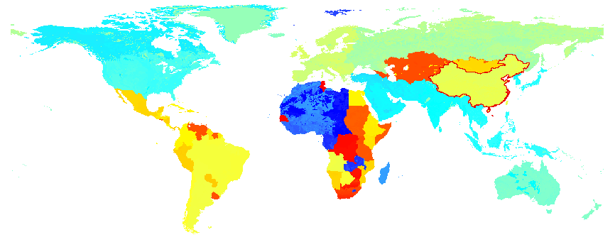
The HWSD is a 30 arc-second raster database with over 16000 different soil mapping units that combines existing regional and national updates of soil information worldwide (SOTER, ESD, Soil Map of China, WISE) with the information contained within the 1:5 000 000 scale FAO-UNESCO Soil Mapof the World (FAO, 1971 1981).
The resulting raster database consists of 21600 rows and 43200 columns, which are linked to harmonized soilproperty data. The use of a standardized structure allows for the linkage of the attribute data with the raster map to display or query the composition interms of soil units and the characterization of selected soil parameters (organic Carbon, pH, water storage capacity, soil depth, cation exchange capacity of the soil and the clay fraction, total exchangeable nutrients, lime and gypsum contents, sodium exchange percentage, salinity, textural class and granulometry).
Reliability of the information contained in the database is variable: the parts of the database that still make use of the Soil Map of the World such as North America, Australia, West Africa and South Asia are considered less reliable, while most of the areas covered by SOTER databases are considered to have the highest reliability (Central and Southern Africa, Latin America and the Caribbean, Central and Eastern Europe).
Data is available via here.
For HWSD data, you need to employ ArcGIS to implement, reading Ref. [3] for details.
And the soil type information, FAO-90 soil classification system (![]() isricu_i9264_001.pdf) is preferred. The implication for the code (attributed by CODE90) represented for FAO-90 is to be understood via HWSD_META.mdb through a table named D_SYMBOL90.
isricu_i9264_001.pdf) is preferred. The implication for the code (attributed by CODE90) represented for FAO-90 is to be understood via HWSD_META.mdb through a table named D_SYMBOL90.
References
[1] Harmonized World Soil Database v 1.2 Online.
[2] Regridded Harmonized World Soil Database v1.2.
[3] HWSD in ArcGIS (Recommended).
[4] A rough tutorial on how to work with the Harmonized World Soil database.
[5] ![]() HWSD.Documentation.V1.2.pdf.
HWSD.Documentation.V1.2.pdf.
https://blog.sciencenet.cn/blog-1148346-897137.html
上一篇:Arcpy: Installing Geoprocessing 64bit
下一篇:降采样方法小结