博文
解读美国爱达荷州6.5级地震
 精选
精选
||
据USGS报道,2020年3月31日23时52分(UTC)美国爱达荷州发生6.5级地震,震源深度10千米,震中位于北纬44.4484度、西经115.1361度(下图中绿圈所示)。

一、简介
美国地震学家的研究表明,该震是北美板块浅层地壳内复杂的走滑断层活动的结果,详见如下报道:
The March 31, 2020, M 6.5 earthquake west of Challis, Idaho (about 120 km northeast of Boise), occurred as the result of complex strike slip faulting within the shallow crust of the North America plate. Preliminary focal mechanism solutions for the event, which describe the style of faulting in an earthquake, indicate slip likely occurred on a steeply dipping fault striking either east-west (right-lateral) or north-south (left-lateral). This earthquake occurred within the Intermountain Seismic Belt, a prominent zone of recorded seismicity in the Intermountain West, and is within the western part of the Centennial Tectonic Belt, an area of southwest-northeast extension north of the Snake River Plain. The quake is about 16 km north-northeast of the Sawtooth fault, a 60-km-long normal fault that extends along the eastern base of the Sawtooth Range.
Historic seismicity in the immediate vicinity of the March 31 earthquake is sparse; no earthquakes of M5+ have occurred within 50 km of this event over the past 50 years, and the most notable historic seismicity in the region occurred about 100 km to the east on the Lost River fault zone. This was the site of the 1983 M6.9 Borah Peak earthquake (October 28, 1983), which was followed by five other M 5+ events over the following year, and most recently a M5.0 earthquake in January 2015, about 60 km to the east of today’s event. The March 31, 2020 event is the largest in Idaho since the Borah Peak earthquake. That event killed 2 in Challis, and resulted in over $12M in damage in the Challis-Mackay area. As of 1 hour after this earthquake, two aftershocks (M 4.6, M 3.6) have been located by the USGS, both to the south of the M 6.5 event.
二、震源机制解
W-phase Moment Tensor (Mww)
Moment
6.860e+18 N-m
Magnitude
6.49 Mww
Depth
13.5 km
Percent DC
50%
Half Duration
4.44 s
Nodal Planes
Plane Strike Dip Rake
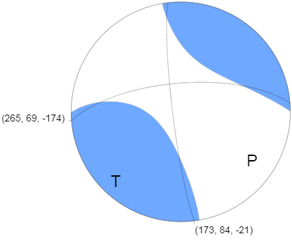
NP1 265° 69° -174°
NP2 173° 84° -21°
Principal Axes
Axis Value Plunge Azimuth
T 7.611e+18 N-m 11° 221°
N -1.904e+18 N-m 68° 338°
P -5.707e+18 N-m 19° 127°

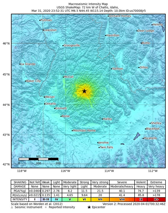
三、宏观地震烈度图
见下图。

上述资料引自:https://earthquake.usgs.gov/earthquakes/eventpage/us70008jr5/executive
四、事件类型
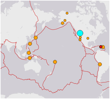
该震发生在旧金山地震区(图1)。关于该区标志性地震的演化规律与地震趋势,我曾写过多篇博文予以介绍。最近的一篇为《解读美国加州近期地震》,感兴趣的童鞋不妨移步看看。

图1 全球地震区划分图
(编号40为旧金山地震区)
为何该地震区的地震们一直不消停呢?这是因为该区当前地震周期尚未结束,在构造运动加载下剩余的锁固段和非锁固段会不断破裂发生地震。
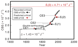
我们判断, 1964年3月28日阿拉斯加南部MW9.3地震(CE3)为一次标志性地震而非主震,故旧金山地震区仍会发生下一次标志性地震;目前距其临界状态尚远(图2)。在其发生前,不论第3锁固段破裂还是非锁固段破裂,必定会发生诸多不同规模的地震——预震,故易知爱达荷州MW6.5地震为一次预震事件。
我们确定的该区最小有效性震级为MW7.0,其界定了锁固段破裂事件的门槛震级,即不小于它,为锁固段破裂事件;小于它,则或为锁固段破裂事件或为非锁固段破裂事件。由于爱达荷州地震的震级小于它,故其不一定是锁固段破裂事件。
对吃瓜群众而言,只要知道爱达荷州MW6.5地震是一次正常的构造地震就欧了。

图2 误差修正后旧金山地震区1523.12.20至2016.2.24之间 MW ≥ 7.0 地震的
CBS与时间关系
(CEs表示标志性地震,其中CE1为1700年1月26日北美卡斯卡迪亚俯冲带MS9.0地震、CE2为1899年1月24日格雷罗Muk8.6/9月10日阿拉斯加湾MS8.6双震、CE3为1964年3月28日阿拉斯加南部MW9.3地震;红虚线为下一次标志性地震的临界CBS值)
美国已确诊的新冠病毒肺炎患者人数已是世界第一啦,爱达荷州地震又造成了雪上加霜的局面,真乃祸不单行啊。对人类而言,病毒、地震、海啸、火山喷发、滑坡、洪涝等均可造成重大的人员伤亡和财产损失,若两种或两种以上的灾害同时来袭,细思极恐呐。为此,建议各国目前除要积极抗疫外,起码还得制定有效的防震减灾措施,以最大程度地减小潜在的损失。
“凡事预则立,不预则废。”愿大家勿忘之!
https://blog.sciencenet.cn/blog-575926-1226339.html
上一篇:日本科学家屡得诺奖靠的是什么精神?
下一篇:撰写“优青”本子应注意什么?