博文
JMS封面文章:江西武功山花岗岩地貌演化阶段及时空变化特征
||
武功山位于江西省中西部,地跨江西省萍乡市芦溪县、吉安市安福县、宜春市袁州区,主脉绵延120余千米,总面积约970平方千米。武功山围绕金顶已设立“武功山国家地质公园”、“武功山国家森林公园”、“明月山国家森林公园”。Joural of Mountain Science 于2022年第10期发表的的文章“Evolution stage, spatial and temporal variabilities of granite landformsin the Mount Wugongshan in Jiangxi Province of South China” 介绍了武功山花岗岩的地貌演化和时空变化。
Citation:
Chai L, Zhong CD, Guo FS, et al. (2022) Evolution stage, spatial and temporal variabilities of granite landformsin the Mount Wugongshan in Jiangxi Province of South China. Journal of Mountain Science 19(10). Journal of Mountain Science (Vol. 19, No.10, 2022). https://doi.org/10.1007/s11629-022-7401-y
Fulltext Downloads
https://link.springer.com/article/10.1007/s11629-022-7401-y
Highlights 文章要点
1)面积-高程积分指示花岗岩地貌演化阶段
2)花岗岩地貌演化具有显著的时空差异性
3)流域规模可能是导致地貌差异的主要原因
Cover Story
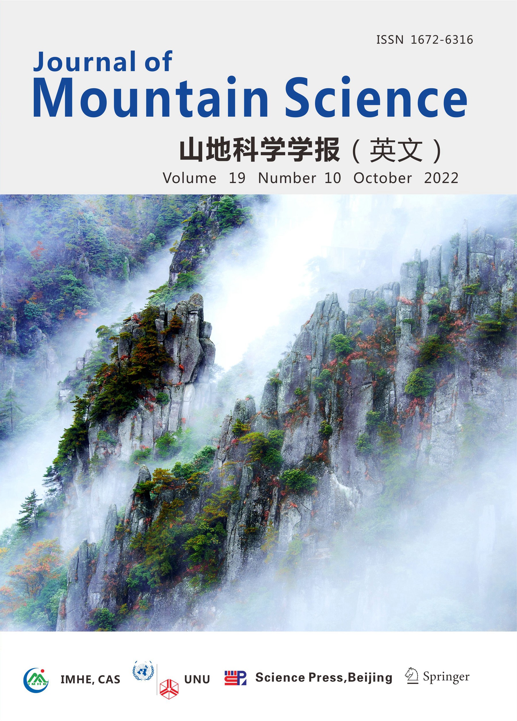
Granite is the most common plutonic rock of the Earth’s crusts, which supports valuable geological tourist attractions in national parks, natural heritage sites and geoparks. It is of great theoretical and practical significance to reveal the temporal and spatial variation of granite landforms by analyzing the differences in evolution patterns and stages in different regions of mountains. Granites of the Mesozoic Era are widespread in South China, and many of them have been shaped into spectacular landscapes with high values of tourism development. Mount Wugongshan is a granite dome structure, which has four kinds of granite landforms, including weathering crust-based alpine meadow, erosion structural landform, runoff erosion landform, and landslide landform. At the outer edge of the main ridge of Mount Wugongshan, granite cliffs, overlapped peaks, peak clusters, stone pillars and other landscapes develop and have extremely high ornamental values.
The cover photo in the current issue of Journal of Mountain Science (Vol. 19, No. 10) shows one of the iconic attractions in the Mount Wugongshan. It was named Shibapai because it looks from a distance like eighteen kinds of weapons on the mountainside. The main part of the Shibapai consists of multiple granite pillars. In the article under the title “Evolution stage, spatial and temporal variabilities of granite landscapes in the Mount Wugongshan in Jiangxi Province of South China”, we studied the evolution of granite landscapes by analyzing the relationship between the Hypsometric Integral curves, Hypsometric Integral values, and factors including the tectonism, lithology and climate. The results show that the differences in watershed scale may be the main reason for the variabilities in geomorphic evolution in the area, while the regular development of tectonic phenomena is a key factor shaping the spatial variability in the watersheds on both sides of the main ridge.
封面故事
花岗岩是地壳中最常见的深成岩,是国内外众多国家公园、自然遗产地或地质公园开展地学旅游关键的构景主体。通过分析不同山地花岗岩地貌演化模式和演化阶段的差异性,揭示花岗岩地貌的时空变化规律,具有重要的理论和现实意义。中国东南部中生代花岗岩分布广泛,形成了各类形态迥异且独具特色的花岗岩地貌景观,具有很高的旅游开发价值。武功山为典型的花岗岩穹窿构造,发育有花岗岩风化壳高山草甸、花岗岩侵蚀构造地貌、花岗岩流水侵蚀地貌和花岗岩崩塌堆积地貌,在其主山脊外缘区域发育花岗岩石崖、峰峦、峰林、峰丛、石柱和其他地貌景观,具有极高的观赏价值。
本期 (第19卷第10期)的封面照片展示了武功山的一个标志性景点,从远处看,犹如十八般武器陈列于此,故名“十八排”。十八排景观主体部分由多根花岗岩石柱组成。在题目为“江西武功山花岗岩地貌演化阶段及时空变化特征”的文章中,我们通过分析面积-高程积分曲线、面积-高程积分值与构造、岩性和气候等因素之间的关系,探讨了武功山花岗岩景观地貌的时空演化规律。结果表明,流域规模的差异性可能是该地区花岗岩地貌演化时空差异的主要原因,而构造现象的规律发展是形成主脊两侧流域空间变异的关键因素。
https://blog.sciencenet.cn/blog-314423-1374666.html
上一篇:JMS表格编辑示例(1)
下一篇:JMS封面文章|海螺沟冰川在“9.5”泸定地震中的稳定性:基于多源观测数据的初步评价